


Nobeltec Marine Navigation app for iPhone and iPad
Developer: MaxSea International
First release : 12 Jun 2013
App size: 260 Mb
"Picking routes, waypoints, and marks on the TZ screen always seem easy and I always seem to find whatever option I might need." Ben Ellison, Panbo.com
"If youre a basic coastal cruiser this app will be a great addition to your Marine navigation tool box." Mark Messerli, i-marineapps.blogspot.com
Nobeltec TimeZero is the ultimate App for marine navigation. More than 95.000 customers around the world already trust TimeZero!
Nobeltec TimeZero is a marine navigation App specially designed for coastal sailors with the most cutting-edge and useful tools & data needed.
Thanks to the outstanding TimeZero technology and PhotoFusion feature, Nobeltec’s marine chart App has a powerful 3D chart engine allowing you to scroll, zoom and rotate the MapMedia Raster charts in no time.
ROBUST TECHNOLOGY & DATA
• 2D/3D chart display engine
• Complete navigation functions in full 2D/3D
• Patented PhotoFusion technology
• MapMedia Raster mm3d charts
BASIC FEATURES
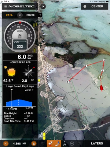
• Your position on the chart
• Course (COG)
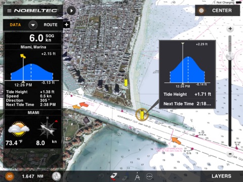
• Speed (SOG)
• Real-time weather and weather trends
• Tides and tidal currents
WHAT’S INSIDE?
• Plot your position in real-time on the most accurate Raster marine charts thanks to the built-in geolocation features of your iPad (GPS and/or WiFi);
• Easily create waypoints and routes;
• Keep as many as 50 routes and display them easily at any time;
• Overlay complete tidal information (tide heights and tidal currents) directly on the chart;
• Thanks to PhotoFusion, overlay satellite photos for a perfect understanding of the coast line;
• Enjoy native compatibility with the FURUNO 1st Watch Wireless Radar (DRS4W) for radar overlay directly across your Apps chart - Radar Module required;
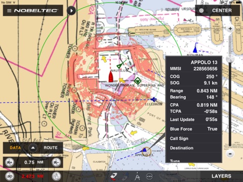
• View AIS targets directly on your Apps chart in real-time - AIS Module required;
• Configure your NavData panel to keep on screen the specific instrument readings that are most useful to you: COG, SOG, Pos, Accu., CTS, NEXT, TTG, DTW, XTE, VMC, ETA, TTA, DTA, Weather;
• Navigate instantly to a waypoint (Go-To tool);
• Choose the chart orientation (Course-Up or North-Up), go back instantly to your vessel (Center On vessel) and switch from 2D to a 3D full view in just one click;
• Undo/Redo feature, don’t worry about doing mistakes;
• Share your position and comments on Facebook.
The ultimate App for marine navigation.
Important Notice: Continued use of GPS running in the background can dramatically decrease battery life.